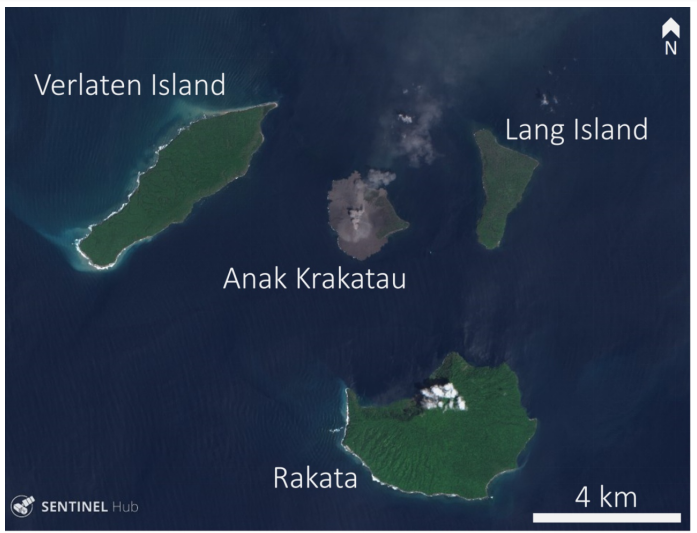
Krakatau Volcano
Krakatoa or the Krakatau is a caldera which is located in the middle of Java and Sumatra in the Indonesian Province at Lampung. The name of the volcanic eruption is named after the surrounding volcanic erupting groups of island comprising of four islands two of which are Lang and Verlaten which were destroyed by the famous volcanic eruption Rakata. The research paper will discuss about the volcanic eruption which has occurred within the time frame of less than six years.
In the year 1927 the fourth island Anak Krakatau or the “Child of Krakatoa”, which had emerged from the caldera that had formed in the year 1883. According to the author Mutaqin, Hadmoko and Ngalawani (2019) there has been much ne activities since the late 20th century after the largest collapse of the deadly tsunami in December 2018. The first notable eruption of the Krakatoa culminated in a series of eruption which had occurred on 26th and continued till 27th August 1883. It was estimated that the volcanic eruption Explosively Index (VEI) of 6, as well as the eruption was equivalent to more than 200 megatons of TNT, that was about 13,000 times the nuclear yield of the Little Boy Bomb which had happened in Hiroshima, Japan during the World War II. The author Nugraha (2019) also says that it was four times the yield of Tsar Bomb which is estimated to be world’s most powerful nuclear device ever denoted in the mountains. According to the author Nugraha (2019) the 1883 eruption of the volcano was approximately covering more than 25 cubic km.
According to the author Hall (2018) the official records of the Dutch East Indies colony, it is found out that more than 165 villages were destroyed and more than 100 town were destroyed near the Krakatoa. It is estimate by the author that almost around more than 36,666 people died in the explosion of the volcano. Also more than 1000 people were injured in the accident or natural calamity that had occurred. It is also believed that more than two thirds of the island of the Krakatoa had in those days. After the eruptions there were a range of new islands which were created after the volcanic eruption in those areas which were named as the Anak Krakatau. Since then there were many periodic eruptions which have occurred since the year 1883. Recent eruptions had occurred in the year 2009, 2010, 2011 and in the year 2012. The major collapse of the tectonic plate movement had occurred in the year 2018. In the late 2011 the radius of the range of islands had increased to more than 2 kilometers. The highest point of the tectonic plate movement was more than 324 meters which is more than 1,063ft above the sea level. In the present date it is found out that every year the land is increasing more than 400mt above the sea level. The following collapse of the volcanoes will extend till the year 2017. According to the author Hall (2018) it is estimated that the height of the volcanoes will be reduced to more than 100 meters above the sea level.
Although there are various types of descriptions related with the Sunda Strait with the pointed mountain in the western regions of the world. About two dozen variants of the volcanic eruptions have been found out. Indonesia in the present era has more than 130 active volcanoes which is more than any nation in the world. Therefore it makes up the axis of Indonesian Island arc system along with the pointed mountains. But historically there has been long confusion about the name and spelling of the volcanic eruption. Few authors have incorrectly made the decision about the distinction between the pre 1883 which was called Krakaota for the current volcanic eruption. Anak Krakato is the name of the present active volcano. The activity of the year 2018 October 21st shows that the volcanic eruption will continue to grow for the next executive years. The lava flows for the year 2018 was considered to be the first eruptions which ha d happened in the year 2018, but duly after that there were no such eruptions. It has also been seen that the satellite images of the volcanic eruptions can occur every alternative year. The satellite images show that there is incandescence in the crater. The lava flows on the SW flank and the incandescent material to the SW flank and the SE mater on the crater were eye witnessed the accounts. The report which was presented by the author Hamilton and Sakazak (2018) shows that the ash plumes were exceeding the sea level of 1.5- 2.4 km of altitude.
A video was also shared by the author in the year 2019 which showed that in the month of October there were very much fog and moisture contains in the area (Tee 2016). The lava fountain also showed that the main reason for the eruption of the volcanoes were found out in the video which was shared by the author in the year 2019. The video of the author shows that Richard Rosocoe video of explosion. The ash plumes were very much louder than the 22nd eruption of volcanoes. After sunset the total time which was involved for the earthquake was around more than 4 hours. PVMBG recorded an eruption in the year 2013 where it showed that the dark plumes were fully across the areas of blocked observations of Arnak krakautu. The first tsunami had occurred in the year. At approximately the 2131dn the sound of the ocean broke out to be the hardest sound of the eruption. After the tsunami had occurred the eruption activity had remained during the interval from 3pm in the afternoon.

Observations in the year 2018, 23rd December shows that the steam ash flumes were based on the surge travelling along the water bodies. The first radar communication were observed in the year 2019 which showed that more than 300 aviation colors were shown in the following diagram of the eruption. The summit of the eruption showed that more than 338mt of pre collapse was found and were reduced to more than 110mt. With this more than hundreds to thousands of thousands of lightning strokes. On the year 2019, the damage which was reported in the year, 78 damaged lodgings were found, 434 damaged boats were found, 181 people were evacuated in the journey. The eruption and tsunami resulted in the island.
According to the news article it has also been found out that after the collapse event o0f the volcanic eruption, there were huge amount of changes in the crop and agricultural procedures. The volcanic eruption also shows that there were a noticeable huge amount of changes in the coastal areas of the region. The shoreline was fully destructed in few seconds. There was a huge amount of destruction in the vegetation and removal of barren lands. As per the satellite images which were captured it can be clearly seen that the new uprooted crater from the mountain top was filled with water and it was an active vent. The changes in the crat6er image were visible by the image which was reported by the satellite image of Sential 2. By January 9th there was a rim formed along the mountain ranges, the formation of the rim was the reaction of the hot molten lava with the cold ocean water. Steamorv huge amount of gas had formed at that time which had led to the formation of lava delta surface with the tephra. But slowly the lava delta form was removed by the high tides and low tides of the ocean. By the time the next images could have been taken the lava delta pack was eventually disappearing slowly.
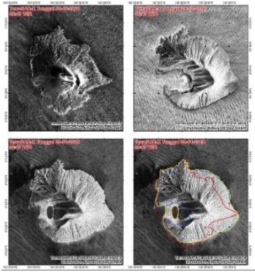
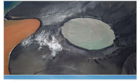
The Terra SAR images which was clicked from the satellite cleanly shows that the morphological changes to the volcanic eruption were very much noticeable in nature. It can be clearly seen that the bottom line images of the mountain shows the part of the southern lava delta that was eventually removed by the volcanic eruption. The material which got removed from the mountain was later on added to the shore of the sea or the ocean which is nearby. The part was added to the south eastern shore of the ocean. Also in the present date there was a drone captured image which clearly shows that due to the volcanic eruption in the country there were two water bodies which had formed. The image which is presented below clearly shows that drone image of the typical formation of an orange colored disclosure water body and the blue color pond of water body. Both of the water bodies were created very recently since the collapse of the hot deposit underneath. The land which can be seen placed between the orange colored lake and the blue color water body is mainly formed due to the hot molten lava flows from the mountain ranges. Despite the creation of the water bodies in the present date it can be seen that the harmful gasses are coming out from the mountain peaks.
References
Mutaqin, B.W., Lavigne, F., Hadmoko, D.S. and Ngalawani, M.N., 2019, April. Volcanic Eruption-Induced Tsunami in Indonesia: A Review. In IOP Conference Series: Earth and Environmental Science (Vol. 256, No. 1, p. 012023). IOP Publishing.
Nugraha, A., 2019. The Existence of Gamelan, Kampong and Mount Krakatoa Eruption Fundraising in Amsterdam Exhibition in 1883.
Hall, S., 2018. World’s first automated volcano forecast predicts Mount Etna’s eruptions: system tracks infrasound waves to determine when an eruption is imminent—and alerts the Italian government. Nature, 563(7732), pp.456-457.
Hamilton, K. and Sakazaki, T., 2018. Exploring the ‘prehistory’of the equatorial stratosphere with observations following major volcanic eruptions. Weather, 73(5), pp.154-159.
Abdurrachman, M., Widiyantoro, S., Priadi, B. and Ismail, T., 2018. Geochemistry and Structure of Krakatoa Volcano in the Sunda Strait, Indonesia. Geosciences, 8(4), p.111.
Plazzotta, M., Séférian, R., Douville, H., Kravitz, B. and Tjiputra, J., 2018. Land surface cooling induced by sulfate geoengineering constrained by major volcanic eruptions. Geophysical Research Letters, 45(11), pp.5663-5671.
Fei, J., Zhang, D.D. and Lee, H.F., 2016. 1600 AD Huaynaputina eruption (Peru), abrupt cooling, and epidemics in China and Korea. Advances in Meteorology, 2016.
Teed, R., 2016. The End-Cretaceous Mass Extinction and the Deccan Traps Eruptions.