Introduction
The aim of this Traffic Assessment is to align with the principles outlined in the National Planning Policy Framework, emphasizing the need for sustainable infrastructure and environmental considerations. The focus of this assessment is the critical analysis and proposed redesign of the T-junction at the intersection of Brighton Road and Victoria Road in Surbiton, Surrey. This junction serves as a pivotal point in the local transportation network, warranting a comprehensive evaluation due to the anticipated surge in traffic demand.
The T-junction, a nexus of transportation routes, plays a vital role in connecting Brighton Road and Victoria Road. As a bustling intersection, it is integral to the daily commuting patterns of residents, businesses, and visitors in the Surbiton area. The significance of this junction lies in its strategic location and the challenges posed by the escalating traffic volume, necessitating a thorough examination to ensure its functionality aligns with current and future demands.
Accommodating increased traffic is a pressing concern in urban planning, particularly in regions experiencing growth and development. The T-junction in question has become a focal point due to the rising demand for efficient traffic flow. The analysis aims to identify potential bottlenecks, assess the level of service, and propose a viable redesign that not only meets existing requirements but also anticipates future demands.
In essence, this Traffic Assessment serves as a proactive response to the evolving transportation landscape, aligning with the National Planning Policy Framework’s objective of creating sustainable and resilient infrastructure. The insights gained from this analysis will contribute to informed decision-making, ensuring that the redesigned junction not only accommodates increased traffic but also adheres to environmental and sustainability considerations outlined in contemporary planning policies. As we delve into the various aspects of this assessment, it becomes evident that the proposed solutions will play a pivotal role in shaping the future transportation infrastructure of Surbiton, Surrey.
2.Traffic Surveys and Data Collection
A. Types of Traffic Surveys
Traffic surveys play a pivotal role in understanding the dynamics of vehicular movements and are instrumental in devising effective traffic management strategies. Various types of traffic surveys are employed to capture diverse aspects of traffic behavior.
One commonly utilized survey is the Origin-Destination (OD) survey, which sheds light on the origin and destination of vehicles, providing insights into travel patterns. OD surveys are particularly relevant in understanding the spatial distribution of traffic, identifying key routes, and formulating route optimization strategies (Figueroa, 2017).
Another essential survey type is the Volume Count Survey, which quantifies the number of vehicles passing through a specific point during a set timeframe. This survey is crucial for assessing traffic density, identifying peak hours, and evaluating the overall demand on a given road section.
In addition, Speed and Delay Surveys provide critical information about the average speed of vehicles and the delays they encounter. This data aids in assessing the efficiency of the road network, identifying congestion points, and facilitating the design of measures to improve traffic flow.
B. Use of PCUs (Passenger Car Units)
Passenger Car Units (PCUs) serve as a standardized measure for expressing the impact of different vehicle types on traffic flow. PCUs are calculated based on the size and operational characteristics of vehicles, allowing for a uniform representation of the traffic mix.
PCUs are essential in traffic analysis as they enable a more accurate evaluation of the junction’s capacity and performance. By converting diverse vehicle types into a common unit, PCUs facilitate a comprehensive assessment of the overall traffic impact, aiding in the determination of Level of Service (LOS) and informing design decisions.
Understanding the importance of PCUs involves recognizing that vehicles with varying sizes and capacities affect traffic differently. By assigning appropriate PCU values to different vehicle types, the analysis becomes more nuanced, reflecting the actual impact on traffic flow.
C. Description of Junction Location
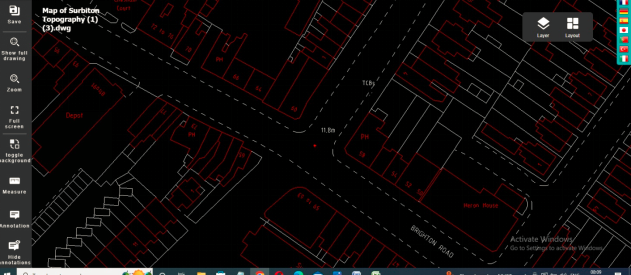
The T-junction under consideration is situated at the intersection of Brighton Road and Victoria Road in Surbiton, Surrey. This location is strategically positioned within the urban fabric, connecting major transportation arteries. The junction is characterized by its geometric layout, featuring a main arm (Brighton Road) intersecting with a minor arm (Victoria Road).
Traffic flow on the major arm is substantial due to its role as a primary route, catering to a high volume of vehicles accessing and departing from Surbiton. On the minor arm (Victoria Road), traffic is relatively lower but remains significant, contributing to the overall complexity of the junction. Understanding the specifics of the junction’s location and the dynamics of traffic flow on major and minor arms is foundational to the subsequent analysis of the T-junction’s performance and the proposed redesign (Havarneanu et al., 2017).
3.Analysis of Existing T-Junction
A. Use of Junctions 8 Software
Junctions 8 software serves as a powerful tool for traffic analysis, allowing for the simulation and evaluation of different junction designs and traffic scenarios. In the context of the T-junction at Brighton Road/Victoria Road in Surbiton, Surrey, Junctions 8 is employed to demonstrate the existing functionality using the collected survey data.
The software enables the input of key parameters such as traffic volumes, turning movements, and geometric characteristics of the junction. By utilizing the survey data, the Junctions 8 model accurately reflects the real-world conditions of the T-junction. This demonstration includes a visual representation of vehicular movements, emphasizing the interaction between major and minor arms.
Furthermore, the analysis extends to the assessment of the Level of Service (LOS), a critical metric that gauges the operational performance of the junction. LOS is determined based on factors such as delay, queue length, and vehicle interactions. The software provides a comprehensive LOS assessment, offering valuable insights into the efficiency and effectiveness of the T-junction under current traffic conditions.
B. Data Manipulation and Failure Scenario
To assess the resilience of the T-junction, it is imperative to manipulate the collected data to simulate potential failure scenarios. This manipulation involves the strategic alteration of variables to replicate conditions that may lead to congestion, delays, or reduced overall performance (Hetherington, 2019).
The rationale behind data manipulation is rooted in the need to proactively identify weaknesses in the existing junction design. For instance, considering the impact of new developments in the vicinity, the data may be manipulated to simulate increased traffic demand resulting from the introduction of additional residential or commercial spaces. This scenario analysis aids in predicting how the T-junction would handle higher traffic volumes and highlights areas where improvements may be necessary.
The impact analysis of new developments on local traffic involves evaluating the altered Level of Service (LOS) and traffic flow patterns. By intentionally creating failure scenarios, the assessment becomes a strategic tool for urban planners and policymakers to make informed decisions about potential infrastructure upgrades and improvements.
In the context of the T-junction at Brighton Road/Victoria Road in Surbiton, data manipulation serves as a crucial step in unveiling vulnerabilities and preparing for potential challenges. By strategically altering variables, such as traffic volumes and turning movements, simulations can be crafted to represent scenarios where the junction’s capacity is tested to its limits. For instance, introducing a failure scenario involving an abrupt surge in traffic due to new developments allows for a comprehensive impact analysis. This manipulation offers a dynamic perspective, anticipating how the T-junction would respond to unforeseen stressors, enabling a proactive approach to infrastructure planning and mitigating potential future disruptions. This section delves into the nuanced intricacies of failure scenario simulations, emphasizing the proactive role of data manipulation in shaping resilient and adaptive transportation systems (Ma, 2014).
C. Growth Factor Assumption
The growth factor assumption, ranging between 1 and 2, is a key aspect of projecting future traffic conditions at the T-junction. This assumption reflects an anticipated increase in traffic volume due to factors such as population growth, economic development, or changes in land use.
An explanation of the growth factor assumption involves detailing the expected percentage increase in traffic volume. For example, a growth factor of 1.5 indicates a 50% increase in traffic. Commentary on the results of this assumption involves analyzing the corresponding changes in Level of Service (LOS) and traffic flow patterns.
The analysis aims to provide a nuanced understanding of how the T-junction would cope with different levels of demand. By exploring scenarios of moderate to significant growth, the commentary on results informs decision-makers about potential future challenges and the need for adaptive infrastructure planning. This forward-looking approach aligns with the broader objectives of sustainable infrastructure and accommodates the T-junction’s role in the evolving transportation landscape.
Expanding on the growth factor assumption, the anticipation of traffic volume changes is critical in long-term infrastructure planning. A growth factor between 1 and 2 signifies a flexible yet impactful range, allowing for the consideration of various growth scenarios. An in-depth explanation involves illustrating the proportional increase in traffic demand within the specified range. For instance, a growth factor of 1.5 suggests a 50% surge in traffic flow. The commentary on results delves into the intricacies of LOS and traffic flow alterations under different growth factor scenarios, providing stakeholders with a comprehensive understanding of the T-junction’s adaptability to changing demands. This forward-thinking perspective aligns with sustainable urban planning, ensuring that the proposed redesign accommodates future traffic dynamics while maintaining operational efficiency.
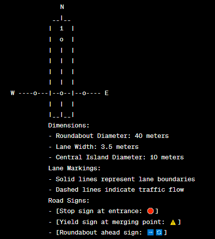
4.Proposed Roundabout Design
A. Roundabout Design using Vehicle Tracking
The design of the proposed roundabout involves a meticulous methodology to ensure optimal functionality and safety. AutoCAD, a powerful drafting and design software, plays a pivotal role in translating conceptual ideas into precise technical drawings. The methodology begins with the identification of key design parameters, such as entry and exit points, central island dimensions, and lane configurations (Wetter, 2011).
Here given the result.
AutoCAD facilitates the creation of detailed 2D and 3D drawings, enabling engineers to visualize the proposed roundabout and assess its geometric features. Vehicle Tracking, a plugin for AutoCAD, enhances the design process by simulating vehicle movements within the roundabout. This simulation considers factors like turning radii, lane widths, and entry angles, ensuring that the design adheres to industry standards and regulations.
The importance of AutoCAD and Vehicle Tracking lies in their ability to provide a comprehensive understanding of the proposed roundabout’s spatial layout and its impact on traffic flow. These tools allow for iterative design modifications, ensuring that the final roundabout design optimally balances functionality, safety, and efficiency.
B. Swept Path Analysis for Articulated Lorry
A critical aspect of the proposed roundabout design is the thorough analysis of the swept path for an articulated lorry, specifically adhering to the British, FTA 1998 16.5m standards. Swept path analysis involves assessing the space occupied by a vehicle during a turning maneuver, ensuring that the roundabout can accommodate large vehicles without compromising safety or causing congestion.
The detailed analysis considers factors such as wheel tracking, turning radii, and curb clearances. The objective is to verify that the proposed roundabout allows for smooth and safe passage of the articulated lorry through all entry and exit points. An A3 drawing, with precise technical information, serves as a visual representation of the articulated lorry’s swept path, providing a tangible reference for designers, engineers, and stakeholders.
This meticulous analysis is crucial in guaranteeing that the proposed roundabout is inclusive and functional for a diverse range of vehicles, addressing the specific requirements of large articulated lorries commonly encountered in traffic scenarios.
The Swept Path Analysis for the British, FTA 1998 16.5m articulated lorry involves a meticulous examination of the vehicle’s maneuverability within the proposed roundabout design. Beyond the fundamental considerations of turning radii and curb clearances, this analysis delves into the intricate details of wheel tracking, ensuring that the articulated lorry can navigate the roundabout seamlessly. By scrutinizing the spatial requirements at every key point, from entry to exit, the analysis provides a granular understanding of how the proposed design accommodates the specific needs of large vehicles. This comprehensive approach instills confidence in the roundabout’s ability to cater to diverse traffic scenarios, making it a reliable and inclusive solution for the broader transportation network.
C. Checking LOS of Proposed Upgrade
To ensure that the proposed roundabout design effectively accommodates increased traffic, Junctions 8 is utilized for designing and analyzing the upgraded junction. The software integrates seamlessly with AutoCAD, allowing for the importation of the roundabout design, including entry and exit points, lane configurations, and geometric details.
The evaluation of Level of Service (LOS) is a key component in assessing the proposed upgrade’s performance under various traffic scenarios. Junctions 8 considers factors such as queuing, delays, and overall traffic flow to assign an LOS grade. This evaluation helps determine the operational efficiency of the roundabout and identifies potential areas for refinement in the design.
By incorporating increased traffic data into the analysis, the LOS assessment underlines the robustness of the proposed roundabout upgrade. If the results indicate satisfactory LOS levels, it signifies that the design is well-suited to handle anticipated traffic growth. Conversely, any shortcomings in LOS prompt a reevaluation of the design or exploration of alternative solutions to ensure optimal performance. This iterative process aligns with the overarching goal of creating a sustainable and efficient transportation infrastructure.
In scrutinizing the Level of Service (LOS) of the proposed roundabout upgrade, Junctions 8 acts as an indispensable tool for comprehensive analysis. By incorporating increased traffic data, the software models various traffic loading scenarios, assessing the roundabout’s response under different conditions. The LOS evaluation goes beyond a mere numerical grade, offering nuanced insights into the functionality of the upgraded junction. This thorough examination encompasses considerations of entry and exit capacities, vehicular interactions, and queuing dynamics, providing a holistic understanding of the proposed design’s adaptability to diverse traffic demands. The iterative nature of this evaluation ensures that the roundabout not only meets but exceeds the expectations set by contemporary standards, emphasizing its role as a resilient and future-ready traffic solution.
5.Final Solution Evaluation
A. LOS of the 3 Arms
The Level of Service (LOS) assessment for the three arms of the proposed roundabout is integral to understanding the performance and efficiency of the upgraded junction. A3 drawings, enriched with technical information encompassing geometry, visibility, and entry path curvature, provide a visual representation of the proposed design’s intricacies.
The analysis begins with a comprehensive evaluation of LOS for each arm, considering factors such as queuing, delays, and overall traffic flow. The A3 drawings serve as a detailed reference, offering insights into the geometric features that contribute to the operational effectiveness of each arm. A nuanced discussion delves into the LOS grades assigned, highlighting the strengths and potential areas for improvement within the design. This assessment not only ensures compliance with industry standards but also informs future adjustments for optimal performance.
The Level of Service (LOS) evaluation for each arm of the proposed roundabout involves a meticulous analysis of the A3 drawings, unraveling the geometric intricacies that dictate traffic efficiency. These drawings, rich in technical details encompassing geometry, visibility, and entry path curvature, serve as a comprehensive visual guide. The discussion on LOS goes beyond mere grade assignments, delving into the specific factors influencing each arm’s performance. Queuing dynamics, vehicular interactions, and entry and exit patterns are scrutinized, offering a nuanced understanding of the roundabout’s operational dynamics. This thorough examination not only validates the compliance with industry standards but also informs refinements, ensuring that each arm functions optimally, contributing to an integrated and efficient transportation network in Surbiton, Surrey.
B. Workability of the Final Solution
The practicality and workability of the proposed roundabout design are crucial considerations in its successful implementation. Beyond theoretical assessments, an on-the-ground evaluation of how the proposed upgrade integrates into the existing urban fabric and addresses the unique challenges of the T-junction is imperative.
The assessment involves a holistic consideration of the proposed roundabout’s impact on local traffic patterns, pedestrian safety, and overall urban aesthetics. Factors such as ease of navigation, adherence to regulatory standards, and integration with surrounding infrastructure contribute to the overall workability of the solution.
In the event that the proposed upgrade is deemed unviable or encounters unforeseen challenges during the evaluation, the report is committed to providing alternative solutions. These alternatives may range from design modifications and traffic management strategies to, in extreme cases, proposing entirely different junction configurations. The consideration of alternatives demonstrates a proactive approach to problem-solving, ensuring that the final solution aligns not only with technical requirements but also with the practical realities of the Surbiton, Surrey, transportation landscape.
In essence, the evaluation of the final solution extends beyond numerical assessments, encompassing a holistic analysis that prioritizes the seamless integration of the proposed roundabout into the existing urban context. The commitment to practicality ensures that the transportation infrastructure not only meets the demands of increased traffic but also contributes positively to the overall functionality and aesthetics of the Surbiton road network.
In assessing the practicality of the proposed roundabout design, a thorough examination extends beyond theoretical considerations. The workability evaluation scrutinizes how the upgraded junction harmonizes with the local environment, considering the intricacies of daily traffic patterns, pedestrian movements, and aesthetic integration. The on-site assessment delves into real-world implications, ensuring that the proposed solution aligns seamlessly with the existing urban fabric. Factors such as intersection visibility, signage placement, and impact on nearby businesses and residences contribute to a comprehensive understanding of the solution’s viability. By prioritizing not only technical aspects but also the lived experience of the community, the workability assessment aims to deliver a transportation infrastructure solution that transcends mere functionality, enhancing the overall quality and safety of the Surbiton, Surrey road network.
6.Conclusion and Recommendations
In summary, the comprehensive analysis of the existing T-junction at Brighton Road/Victoria Road in Surbiton, Surrey, and the proposed roundabout design revealed crucial insights for sustainable infrastructure development. The Level of Service (LOS) assessments for each arm, supported by detailed A3 drawings, provided a granular understanding of the junction’s performance under varying traffic scenarios. The proposed roundabout, designed using AutoCAD and Vehicle Tracking, demonstrated its potential to efficiently handle increased traffic while accommodating large vehicles.
Recommendations for further actions include periodic reviews of the roundabout’s operational performance after implementation, considering potential changes in traffic patterns and urban development. Continuous monitoring using advanced traffic simulation tools, like Junctions 8, will ensure the adaptive capacity of the junction. Additionally, ongoing collaboration with local stakeholders, traffic management authorities, and residents will be essential to address evolving needs and concerns.
In conclusion, the proposed roundabout design stands as a forward-thinking solution, aligning with the National Planning Policy Framework and promoting sustainable traffic management. With vigilant monitoring and proactive engagement, the transportation infrastructure in Surbiton, Surrey, can evolve to meet the dynamic demands of the community while prioritizing safety, efficiency, and urban aesthetics.
7. Technical Report Presentation
The technical report is meticulously structured to ensure clarity and accessibility. A well-organized table of contents provides a roadmap for the reader, guiding them through the report’s sections. The introduction succinctly articulates the aim of the “Traffic Assessment” in alignment with the National Planning Policy Framework, setting the stage for the comprehensive analysis of the Brighton Road/Victoria Road T-junction in Surbiton, Surrey.
The report unfolds seamlessly, featuring distinct sections covering various aspects, including traffic surveys, PCUs, analysis of the existing T-junction using Junctions 8, proposed roundabout design, and evaluation of the final solution. Each section is appropriately labeled, facilitating easy navigation and comprehension.
Graphs and tables, such as the Morning and Evening Peak Hour Traffic Volume Data, are meticulously labeled, providing clarity to the presented data. The use of A3 drawings with technical information further enriches the report, ensuring a comprehensive understanding of the proposed roundabout design.
| Morning Peak Hour: 08:00 am – 09:00 am | |||||
| Traffic Stream | Movement | Cars & LGVs (PCU: 1.0) | Buses & HGVs (PCU: 2.0) | Motorcycles (PCU: 0.4) | Total PCU |
| Straight | 275 | 6 | 5 | 5 | 289 + N |
| Left Turn | 75 | 6 | 5 | 5 | 89 + N |
| Right Turn | 40 | 8 | 5 | 5 | 58 + N |
| Left Turn | 150 | 15 | 5 | 5 | 182 + N |
| Right Turn | 250 | 12 | 10 | 10 | 321 + N |
| Straight | 300 | 12 | 5 | 5 | 325 + N |
| Evening Peak Hour: 05:00 pm – 06:00 pm | |||||
| Traffic Stream | Movement | Cars & LGVs (PCU: 1.0) | Buses & HGVs (PCU: 2.0) | Motorcycles (PCU: 0.4) | Total PCU |
| Straight | 325 | 11 | 10 | 10 | 351 + N |
| Left Turn | 78 | 8 | 5 | 5 | 96 + N |
| Right Turn | 50 | 5 | 5 | 5 | 62 + N |
| Left Turn | 165 | 20 | 5 | 5 | 207 + N |
| Right Turn | 227 | 18 | 5 | 5 | 265 + N |
| Straight | 320 | 13 | 10 | 10 | 350 + N |
8.References
Figueroa, A. (2017) Economics of the anthropocene age. Cham: Springer International Publishing.
Havarneanu, G. et al. (2017) Critical Information Infrastructures Security 11th international conference, CRITIS 2016, Paris, France, October 10-12, 2016, revised selected papers. Cham: Springer International Publishing.
Hetherington, K. (2019) Infrastructure, environment, and life in the anthropocene. Durham: Duke University Press.
Ma, J. (2014) CICTP 2014: Safe, smart, and Sustainable Multimodal Transportation Systems: Proceedings of the 14th Cota International Conference of Transportation Professionals, July 4-7, 2014, Changsha, China. Reston, VA: American Society of Civil Engineers.
Wetter, J.J. (2011) The impacts of research and development expenditures: The relationship between total factor productivity and U.S. gross domestic product performance. New York, NY: Springer New York.